We want to give an overview of the current products from Skydemon, ForeFlight and Garmin Pilot. The report is intended to give an impression of the capabilities and features of the individual products and how they can be used. We also provide links to websites and videos for further information. Many of the products also offer a free trial period so that the software can be tested extensively in real use before deciding on a product.
Skydemon
In the world of private aviation, precise planning and execution of flights is essential for safety and efficiency. This is where SkyDemon comes in, a leading software solution designed specifically for pilots.
What is SkyDemon?
SkyDemon is a comprehensive flight planning and navigation software that is widely used in Europe. The software is available for the PC as well as for iOS and Android and offers a variety of functions that are particularly tailored to the needs of VFR (Visual Flight Rules) pilots. IFR flights can also be planned and carried out with it, but its strengths lie particularly in the VFR area.
Core functions of SkyDemon:
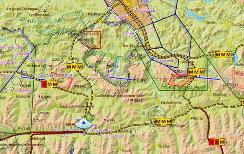
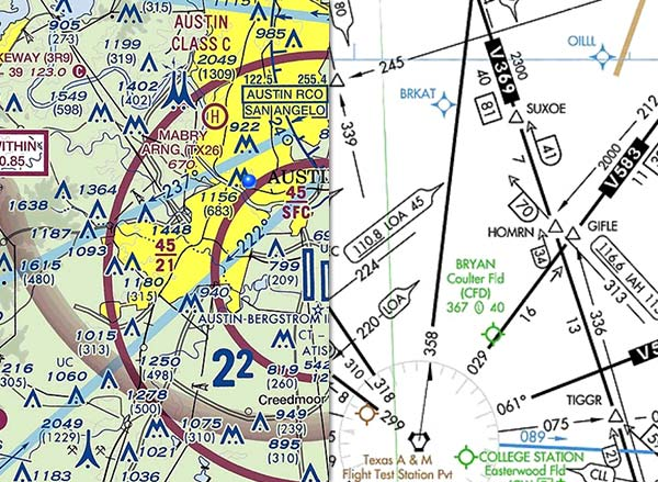
- Detailed aeronautical chartsThe software offers highly detailed maps that have been specially developed for aviation. These maps are interactive and provide information on airspaces, aerodromes and navigation aids. They are vector graphics that can be zoomed in and out to provide both an overview and detailed information. SkyDemon offers detailed aeronautical charts for Europe and North America.
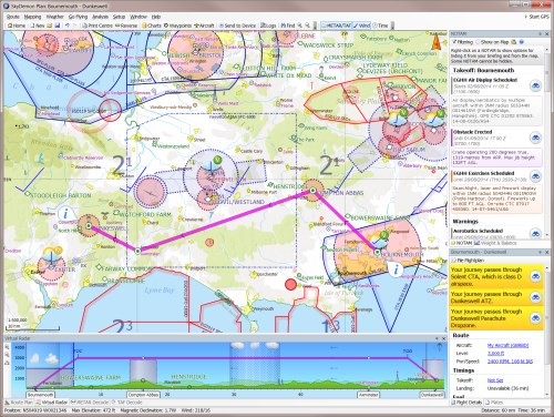
- Dynamic route planningSkyDemon allows pilots to plan their flight routes interactively. The software takes into account airspace, weather conditions and aerodrome data to create a safe and efficient route. The software allows you to enter the departure and destination airports, route, altitude and cruising speed. SkyDemon then calculates the flight time, distance and fuel consumption.
- Real-time flight trackingSkyDemon offers real-time navigation during the flight, allowing the pilot to constantly monitor the flight route, position and important flight information.
- Weather informationSkyDemon integrates weather data directly into the maps so that pilots receive up-to-date information about weather conditions along their route.
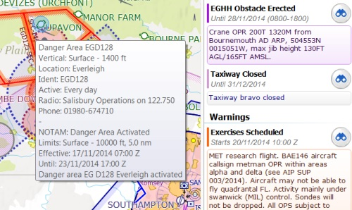
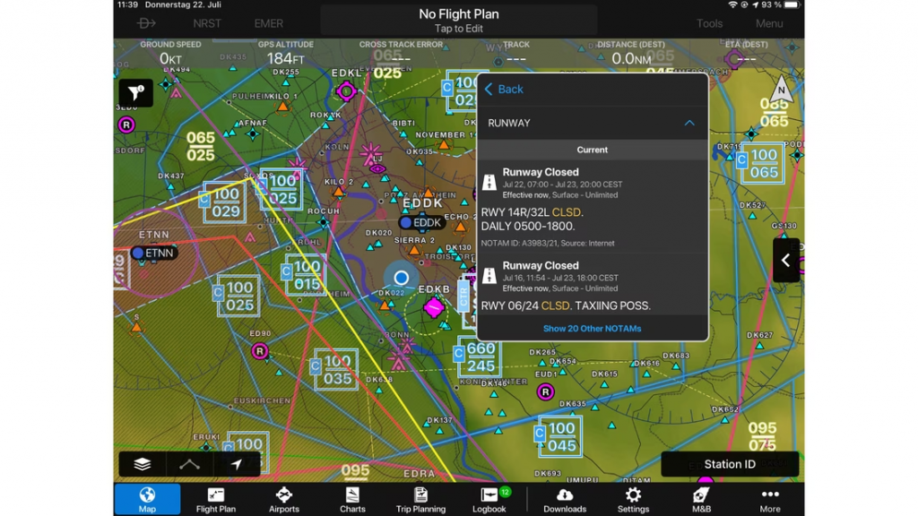
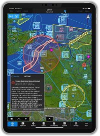
- NOTAMs: SkyDemon displays NOTAMs (Notices to Airmen) for your flight route. NOTAMs contain important information about airspace restrictions, dangerous areas and other events that may affect your flight planning.
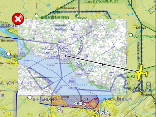
- Moving Map: SkyDemon's Moving Map function shows you your current position on the map. You can use the moving map to track your route and reach your destination. Specific approach charts can be displayed directly on the map as an overlay.
- Traffic information: SkyDemon displays traffic reports for your flight route. This includes information about other aircraft in your vicinity.
- Flight data managementPilots can manage their flight logs and data directly in the software, making it easier to follow up and analyse flights.
Installation and access
Download and installation
SkyDemon is intuitive and easy to use software. The user interface is clear and concise and the functions are easy to find. The software also offers a range of tutorials and help documents that can help you familiarise yourself with the software.
SkyDemon is available for the PC as well as an app via the Apple App Store or Google Play Store. After downloading and installing the app, you must register for a subscription to access all functions.
First steps
After logging in, SkyDemon will guide you through a setup process where you enter your aircraft data and configure the software according to your preferences. This step is crucial as the accuracy of the flight calculations depends on the correctness of this data.
Flight planning with SkyDemon
Planning a route
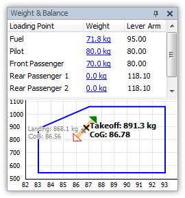
To plan a route, start by selecting your starting point and destination on the map. SkyDemon automatically displays various route suggestions, taking into account airspace and other relevant data. You can customise the route manually by adding or removing waypoints. All tasks such as fuel calculation, weight and balance and more can also be performed in the software.
Analysing the flight route
Once the route has been determined, SkyDemon provides a detailed analysis of the planned flight route. This includes information on airspace crossings, NOTAMs (Notice to Airmen) and weather conditions. This information is important for deciding whether and how a flight should be carried out.
Use during the flight
During the flight, SkyDemon provides a real-time navigation view that displays your current position, the planned route and important navigation information. The software also warns you of potential hazards such as airspace violations or significant weather changes.
Further resources
To get the most out of SkyDemon, we recommend watching the official SkyDemon tutorials and demonstration videos. These can be found directly on the SkyDemon website or on their YouTube channel. These resources provide valuable insights and tips on how to use the software effectively in various flight scenarios.
The manufacturer's website: SkyDemon website
SkyDemon Tutorial - Getting Started: Skydemon Tutorial
List with many detailed videos about Skydemon: Skydemon videos
SkyDemon tutorials in German with a focus on Switzerland: Focus Switzerland
*****
ForeFlight
Introduction
ForeFlight is one of the leading mobile apps for flight planning, weather reports, flight tracking and more. This report offers a brief insight into the functionalities and applications of ForeFlight, specifically tailored to the needs of private pilots. We describe how ForeFlight supports flight preparation, execution and post-processing and how pilots can integrate these tools into their daily flight routines.
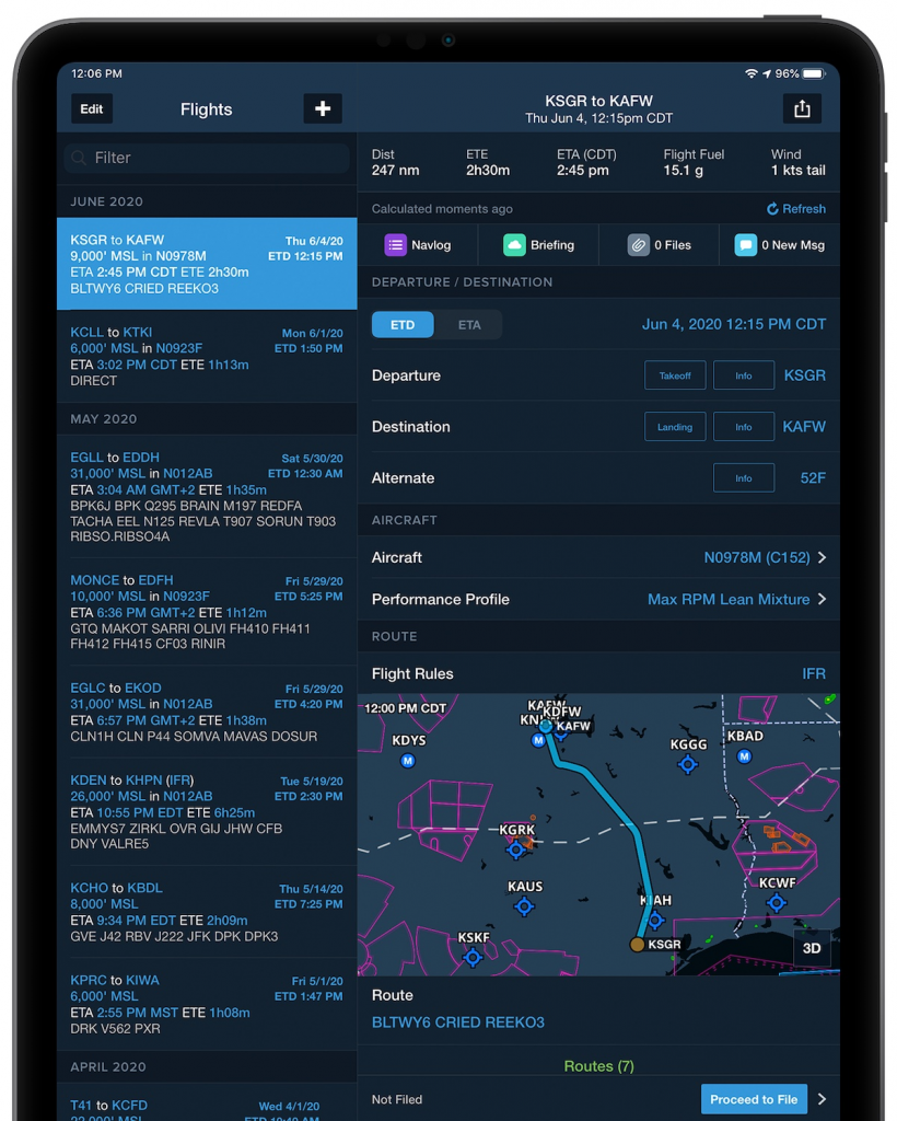
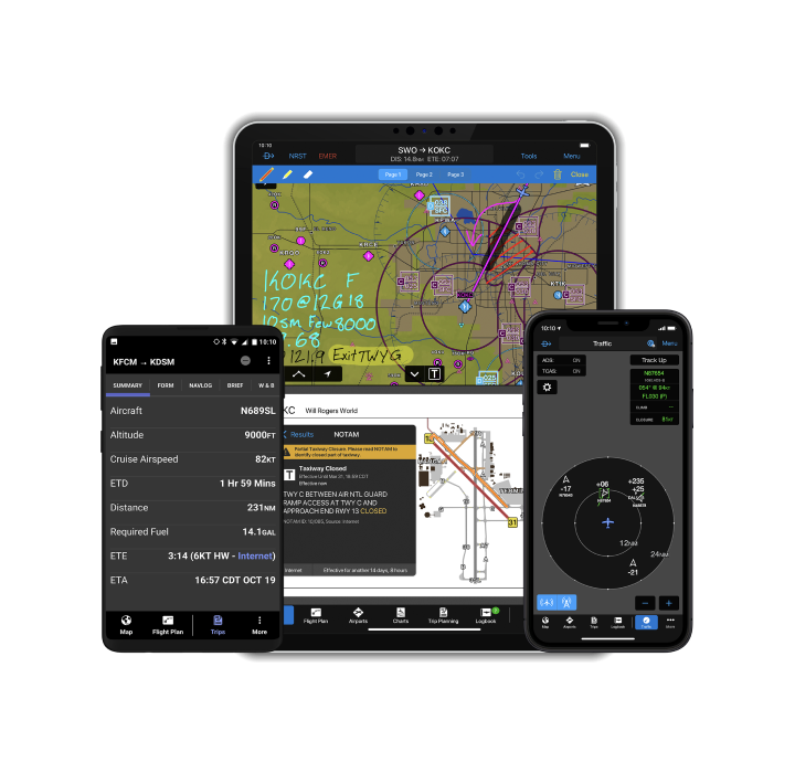
ForeFlight is a comprehensive mobile software solution for pilots of all classes. Originally launched as a simple flight planning app, ForeFlight has developed into a multifunctional tool that offers detailed weather data, comprehensive aeronautical data, dynamic maps, flight planning functions and real-time flight tracking. ForeFlight shows its strengths especially in the IFR area. The common Jeppessen charts can be integrated via the software, IFR flight routes can be calculated and IFR flight plans can be submitted directly.
Main functions of ForeFlight:
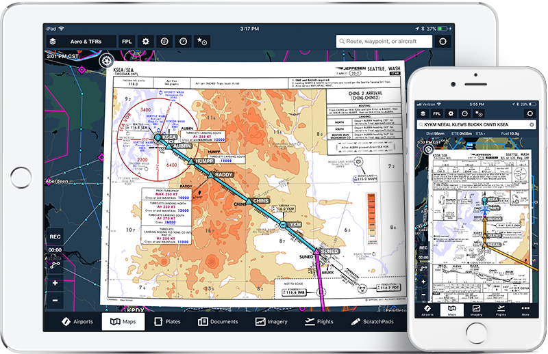
- Interactive mapsForeFlight offers detailed VFR and IFR aeronautical charts for the whole world. The charts can be displayed in different scales and contain information about aerodromes, airspace, navigation aids and other important points.
- Flight planning: ForeFlight makes it easy to plan flights. The software allows you to enter the departure and destination airports, route, altitude and travelling speed. ForeFlight then calculates the flight time, distance and fuel consumption.
- Weather reports and forecastsForeFlight provides up-to-date weather information for the whole world. You can view the weather forecast for your departure and destination airports as well as for en route.
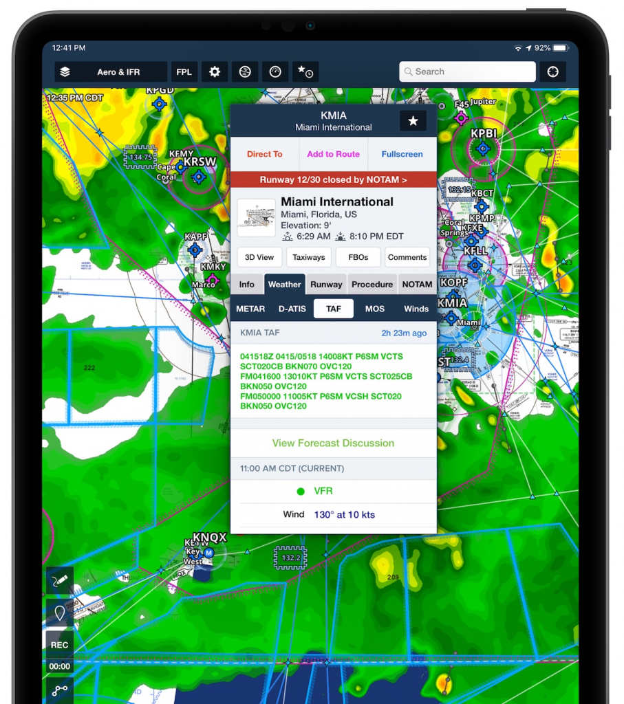
- NOTAMs: ForeFlight displays NOTAMs (Notices to Airmen) for your flight route. NOTAMs contain important information about airspace restrictions, dangerous areas and other events that may affect your flight planning.
- Airspace information: ForeFlight displays airspace information for your flight route. This includes the type of airspace, the flight altitude and the radio frequencies.
- Moving Map: ForeFlight's Moving Map function shows you your current position on the map. You can use the moving map to track your route and reach your destination. Approach charts (important for the IFR area: also the Jeppesen charts) can be integrated directly into the moving map as an overlay.
- Traffic information: ForeFlight shows you traffic reports for your flight route. This includes information about other aircraft in your vicinity.
- Flight schedules: VFR and IFR flight plans can be calculated and then submitted directly from the software in compliance with Eurocontrol.
- Flight loggingAutomatic flight logging to simplify flight recording.
- Weight & Balance: Calculations for weight and centre of gravity distribution.
- Digital document managementStorage and organisation of flight documents.
- Additional functions: ForeFlight offers a range of additional functions, such as
- Synthetic Vision: Synthetic Vision generates a 3D view of the terrain and airspace that helps you to better perceive your surroundings.
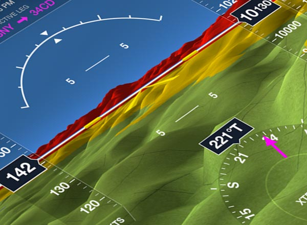
- Terrain Awareness & Warning System (TAWS): TAWS warns you of dangerous terrain, such as mountains and high-voltage power lines.
- Flight Instruments: ForeFlight offers a range of virtual aircraft instruments, such as altimeter, airspeed indicator and heading indicator.
Installation and basic configuration
The user interface is clear and concise and the functions are easy to find. The software also offers a range of tutorials and help documents that can help you familiarise yourself with the software.
ForeFlight is available in the Apple App Store and requires an iOS device. Although there is also a version that can be accessed via the browser, this only has very limited functions. Once downloaded, users install the app and register for one of the various subscription services ForeFlight offers, depending on the user's needs and requirements.
First steps
After installation, ForeFlight guides new users through a configuration process in which personal preferences, aircraft data and other important information are set. This initial configuration is crucial for the app's accuracy in flight planning and performance calculation.
Flight planning with ForeFlight
Planning a route
To plan a route, users enter start and destination points in the search bar. ForeFlight automatically generates a flight route taking into account airspace, weather conditions and other relevant factors. Users can customise the suggested route by adding or removing waypoints. ForeFlight also allows users to calculate Eurocontrol compliant IFR flight routes and then file IFR flight plans directly from the app.
Analysis and weather
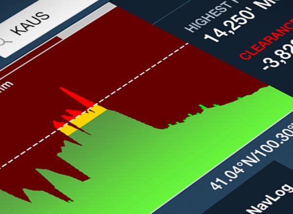
ForeFlight provides an in-depth analysis of the planned route, including the display of weather conditions, NOTAMs and airspace information. This information is accessible via the profile view, which provides a side view of the route with overlaid weather data and airspace boundaries.
During the flight
Navigation and tracking
In flight, ForeFlight displays the planned route together with a range of navigation aids such as GPS tracking, speed, altitude and heading. The moving map means you can always see exactly where you are, similar to navigation software for cars. The app also offers a synthetic view, which helps to supplement the outside view in poor visibility conditions.
Security features
ForeFlight includes several safety features such as terrain and obstacle warnings as well as real-time traffic updates that can be obtained via ADS-B or other in-flight services.
Further resources
For more in-depth guidance, we recommend watching the tutorial videos and instruction manuals directly on the ForeFlight website or via their YouTube channel. These resources are specifically designed to help new users get started and provide experienced pilots with advanced tips and tricks.
Website of the manufacturer: ForeFlight website
Tutorial Video: ForeFlight Tutorial
Collection of videos with detailed information: ForeFlight videos
***
Garmin Pilot:
Introduction
Garmin Pilot is one of the leading mobile apps for flight navigation and flight planning, developed specifically for the needs of private pilots. With a wide range of functions, from detailed route planning to real-time flight monitoring, Garmin Pilot offers support in digital flight assistance. This report provides insights into the functionalities, operation and utilisation both before and during the flight.
Overview of Garmin Pilot
Garmin Pilot seamlessly integrates global flight planning tools, comprehensive digital maps, advanced navigation, an extensive database of airports and their facilities, and dynamic weather information. These features make Garmin Pilot an all-in-one app that fulfils the needs of both VFR (Visual Flight Rules) and IFR (Instrument Flight Rules) pilots.
Core functions
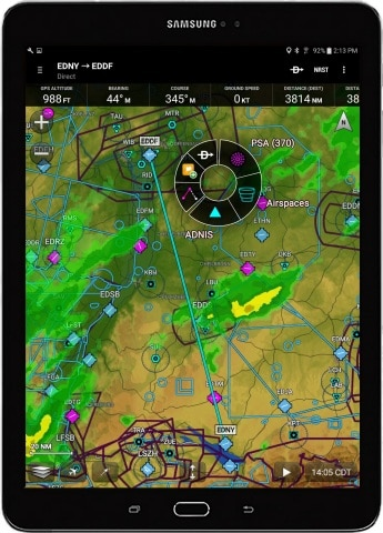
- Interactive mapsHigh-quality aeronautical charts for the entire world, including aerodromes, airspace, navigation aids and important points. Access to VFR and IFR charts that update automatically.
- Flight planningEasy creation and editing of flight plans with automatic route optimisation. Intuitive creation of routes with departure and destination airports, route planning, flight altitude and cruising speed.
- Weather monitoringReal-time weather radar, METARs, TAFs and winds aloft.
- NOTAMs and airspace information: Access to current NOTAMs (Notices to Airmen) and airspace information for the planned flight route.
- Moving Map: Real-time display of the current position on the map with route tracking and destination guidance.
- Traffic reports: Warnings of other aircraft in the vicinity for increased safety in the airspace.
- Document managementElectronic PIF (Pilot Information File) for storing important documents and checklists.
- Synthetic vision3D view of the surroundings, showing terrain, obstacles and the flight path.
- LogbookAutomatic recording of flight data for easy monitoring and reporting.
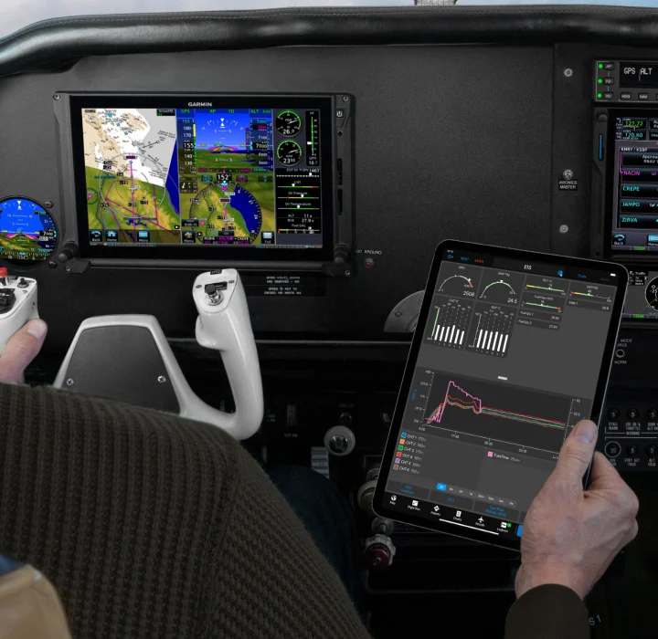
- Connection with Garmin hardware in the aircraftAs you might expect, this works extremely well within the Garmin ecosystem
Installation and setup
Garmin Pilot is available for iOS and Android devices and can be downloaded from the Apple App Store or Google Play Store. After installing the app, users must create a Garmin account or log in to access the services.
Configuration
After the first login, pilots are asked to set up their aircraft profile, including information on aircraft type, registration number, performance data and weight and centre of gravity restrictions. This data is crucial as it forms the basis for all flight planning and performance calculations.
Flight planning with Garmin Pilot
Create a route
Planning begins with the input of start and destination points. Garmin Pilot uses advanced algorithms to calculate the optimal route based on set preferences and current airspace data. Users can add or remove waypoints and customise the route to their specific requirements.
Flight planning tools
Garmin Pilot offers comprehensive tools for analysing the flight route, including fuel consumption, flight time calculation and alternative airports. Users can also get a detailed weather overview, which helps to adjust flight planning accordingly.
Use during the flight
In-Flight Features
During the flight, Garmin Pilot offers real-time navigation based on GPS data. The app displays information such as current position, speed, altitude and heading directly on the moving map. The app also warns of potential dangers such as airspace violations or weather changes.
Cockpit integration
Garmin Pilot can be synchronised with external Garmin devices in the cockpit, enabling seamless integration of mobile and fixed systems. This expands functionality and improves the overall cockpit experience.
Further resources
Garmin offers an extensive collection of tutorials, user guides and FAQ pages to help users get the most out of the app. These resources are directly accessible via the Garmin website or the help section in the app.
As part of the Garmin ecosystem, Garmin Pilot users can also access a vibrant community of like-minded people, share experiences and send feedback directly to Garmin.
Website of the manufacturer: Website Garmin Pilot
In addition, Garmin offers a range of tutorials and help documents to assist pilots in familiarising themselves with the software: Garmin Pilot Tutorial
Garmin Pilot video training series: Garmin Pilot videos