First the most important links for weather briefing, NOTAMs and AIP
Valid for Germany (expand)
- Flying weather preparation: DWD aviation weather (with pc_met access, i.e. the DWD's fee-based access) or as free access (with limited scope): DWD free access
- The relevant DWD apps are "DWD FlugWetter" and "DWD Warnwetter"
- NOTAMs, AIP, task flight plans: AIS - DFS
Valid for Austria (expand)
- Aviation weather data is transmitted via Austro Control MET (Austro Control Weather) are provided. METAR, TAF, SIGMET and GAFOR are included. Aeronautical weather advice is available by telephone on +43 (0) 5 1703 3222.
- NOTAMs, AIP, task flight plans: Homebriefing
Valid for Switzerland (expand)
- MeteoSwiss offers comprehensive aviation weather information about MeteoSwiss. GAFOR, GAMET, TAF and METAR are available.
- NOTAMs, AIP, task flight plans: Skybriecaught
Flight preparation is a very important process that involves various steps to ensure safety, efficiency and also compliance with regulations for flight operations. These preparations include extensive checks of weather conditions, route planning, loading, fuel management, legal requirements and emergency preparedness. The integration of additional information from external sources should provide a comprehensive picture for flight preparation.
Weather briefing
The weather briefing is crucial to ensure flight safety.
Pilots must keep themselves informed about the current and forecast weather conditions along their flight route and at their destination.
Valid for Germany (expand)
In Germany, the websites of the German Weather Service DWD and its (chargeable) "pc_met" access via DWD flying weather. You can also get personalised aviation weather advice by telephone from a DWD employee at any time. The DWD offers a wide range of services and information for Germany. For more information see: DWD flight counselling.
Valid for Austria (expand)
Aviation weather data is transmitted via Austro Control MET (Austro Control Weather) are provided. METAR, TAF, SIGMET and GAFOR are included. Aeronautical weather advice is available by telephone on +43 (0) 5 1703 3222.
Valid for Switzerland (expand)
MeteoSwiss offers comprehensive aviation weather information about MeteoSwiss. GAFOR, GAMET, TAF and METAR are available. Particularly relevant when crossing the Alps.
Internationally, there are websites such as the Aviation Weather Centre (AWC) of the National Oceanic and Atmospheric Administration (NOAA) at NOAA.
These sites provide comprehensive weather information, including TAFs (Terminal Aerodrome Forecasts), METARs (Meteorological Aerodrome Reports), SIGMETs (Significant Meteorological Information) and AIRMETs (Airmen's Meteorological Information). In addition to these websites, specialised services such as those from well-known flight preparation apps like SkyDemon or ForeFlight can be used to provide weather data and flight planning tools in one integrated platform. We will go into more detail on software and apps in other articles.
A thorough weather briefing is of central importance for flight preparation and takes place in several phases. Different types of information are obtained, which are tailored to the time before the planned flight. The weather briefing can be structured as follows:
Long-term weather forecasts (several days before the planned flight):
The following information should be obtained here
- General weather trend: Obtaining information on large-scale weather developments and systems that could affect the flying area. This includes high and low pressure areas and their predicted movement and development.
- Temperatures and precipitation probabilities: Estimation of temperatures and the probability of precipitation and its type (rain, snow, hail).
- Wind conditions: Information on the expected wind conditions, including wind direction and speed at various flight altitudes.
- Special weather phenomena: Indications of special weather phenomena such as thunderstorms, heavy rain or fog that could be relevant for the flight route.
Of course, the closer you get to the departure date, the more detailed information you should obtain.
Sources: The country-specific sites mentioned offer long-term forecasts. These general weather forecasts are helpful for an initial assessment.
Detailed weather briefing the evening before the flight
The above information must be supplemented with local details that are now available:
- Local weather conditions: Detailed information about the weather conditions at the departure and destination airports and along the route.
- Sigmet and Airmet information: Specific warnings of significant meteorological events relevant to aviation, such as turbulence, icing and poor visibility.
- Weather radar and satellite images: Use of weather radar and satellite images to visualise precipitation fields and cloud formations.
Sources: More specific forecasts and current weather data can be called up on the websites mentioned above or via the familiar apps.
Final weather briefing shortly before the flight
Current weather conditions and short-term forecasts should always be obtained before the flight:
- METARs and TAFs: Check the latest METAR reports (current weather conditions) and TAF reports (weather forecasts) for take-off, destination and alternative aerodromes.
- NOTAMs: Check for weather-related NOTAMs (Notices to Airmen), which may indicate temporary changes or restrictions such as closed runways due to snowfall.
- Winds Aloft: Information on wind conditions at different altitudes to optimise the flight route and altitude.
- Latest changes: Consideration of short-term changes in weather conditions that could affect the flight.
Sources: In addition to the websites mentioned above, direct contact with an aviation weather consultant can also be useful for the final weather briefing in order to clarify any final uncertainties and obtain a professional assessment of the weather situation and possible effects on the flight.
For all phases of the weather briefing, the information must come from reputable and up-to-date sources and should be carefully evaluated in the context of the flight planning. A comprehensive understanding of the weather conditions is essential for flight planning.
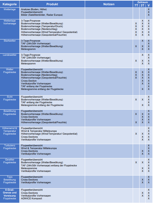
Valid for Germany (expand)
The following DWD table provides an overview of which DWD products are suitable for flight preparation. As part of flight training, you familiarise yourself with these products and learn to "read" them. The DWD also offers regular flying weather seminars.
Route planning
Route planning includes the selection of the flight path, taking into account airspace structures, flight restriction areas, availability of navigation aids and possible emergency landing sites.
During training, you learn to plan your route "by hand" using charts, an angle triangle and a navigation computer. In later flying life, you will certainly also use tools and software for this.
There is a separate article on the topic of "Software products" in the Academy.
These products provide support by making aeronautical charts available online, on which airspaces, airports and navigation-relevant information are marked. The tools then automatically provide flight planning, including course calculation, taking wind conditions into account.
When planning a flight, a number of things have to be taken into account, such as airspace structures, danger areas, minimum flight altitudes and details of the respective aerodromes.
Fuel management and loading
For the fuel calculation, pilots must calculate the total fuel consumption, which covers the total flight time, additional fuel for unforeseen circumstances and reserves for the flight to an alternative aerodrome. Again, pilot training teaches you how to do these calculations by hand. Programmes such as ForeFlight or SkyDemon offer tools for calculating fuel requirements based on aircraft type, speed, wind conditions and route.
Load planning is an equally central and important part of flight preparation. It requires precise consideration of the maximum permissible take-off weight (MTOM - Maximum Take-Off Mass) and the centre of gravity. The correct weight and balance calculation is essential for flight safety, as it influences the aircraft's flight performance and handling. Many flight planning software offer integrated tools for weight and centre of gravity calculation.
NOTAMs, AIP, legal requirements and flight plans
Knowledge of current aviation laws and regulations is essential. In many countries, including the United States and European Union member states, digital platforms such as the FAA's PilotWeb and the European AIS Database (EAD) portal are available to provide access to NOTAMs, AIPs (Aeronautical Information Publications) and other important regulatory information.
In Germany, access is via: AIS - DFSIn Austria via: Homebriefing; in Switzerland via: Skybriecaught.
It gives you access to the AIP (Aeronautical Information Publication) for VFR and IFR as the most important source for all rules and regulations to be observed. It is essential to read this document. Even if the essential regulations are internationally regulated by the ICAO, there are still country-specific particularities. Therefore, you should, for example, check the AIP documents of the respective country before every trip abroad. The AIP contains general guidelines, specifications for cross-country flights as well as detailed information on all aerodromes in the country.
For international flights, there are often additional specific requirements to consider, such as customs and immigration regulations, overflight rights and the filing of flight plans. The International Civil Aviation Organisation (ICAO) provides guidelines for international flights, including the need to file flight plans and have the necessary documents ready for the flight.
In addition to the AIP, there are the NOTAMs (Notice to Airmen) in which important information is published at short notice, such as entry restrictions, availability of radio navigation equipment, special obstacles, restrictions at airports and much more. It is absolutely essential to read the relevant NOTAMs in detail before every flight.
Finally, you will also find the option to submit flight plans under the links above. In Germany, Austria and Switzerland this is necessary for VFR night flights or for all IFR flights in general. Details on flight plans and how to fill them in can be found elsewhere in the Pilot Hub. Various tools and software products also make this much easier.
Emergency preparedness
Pilots should also think about emergency situations before every flight and prepare for them as well as possible. This includes checking emergency equipment and procedures. If flying over the sea, life jackets should be worn in advance and if flying over remote areas, survival equipment should be carried. Knowledge of procedures in the event of radio failure and preparation for possible emergency landings is of course learnt during training, but should always be remembered before every flight.
Summary
Conscientious preparation is part of every flight. You should take a close look at the weather en route and at the respective aerodromes. Local conditions, airspace structures, NOTAMs and other factors must be taken into account when planning the route. A fuel and centre of gravity calculation must also be carried out for each flight. Nowadays, there is a lot of support for flight preparation in the form of tools, apps and software. However, the pilot must have the necessary understanding.